This new stage has a little bit more than 25 kilometres that go through flat land, typical from Castile. The original Way does not goes through Atapuerca but if you want to go and visit this wonderful site you can go through a turn away that is well indicated. You can also take a turn away to avoid the industrial area at the entrance of Burgos, if you use this turn away you will go through a path next to the Arlanzón river.
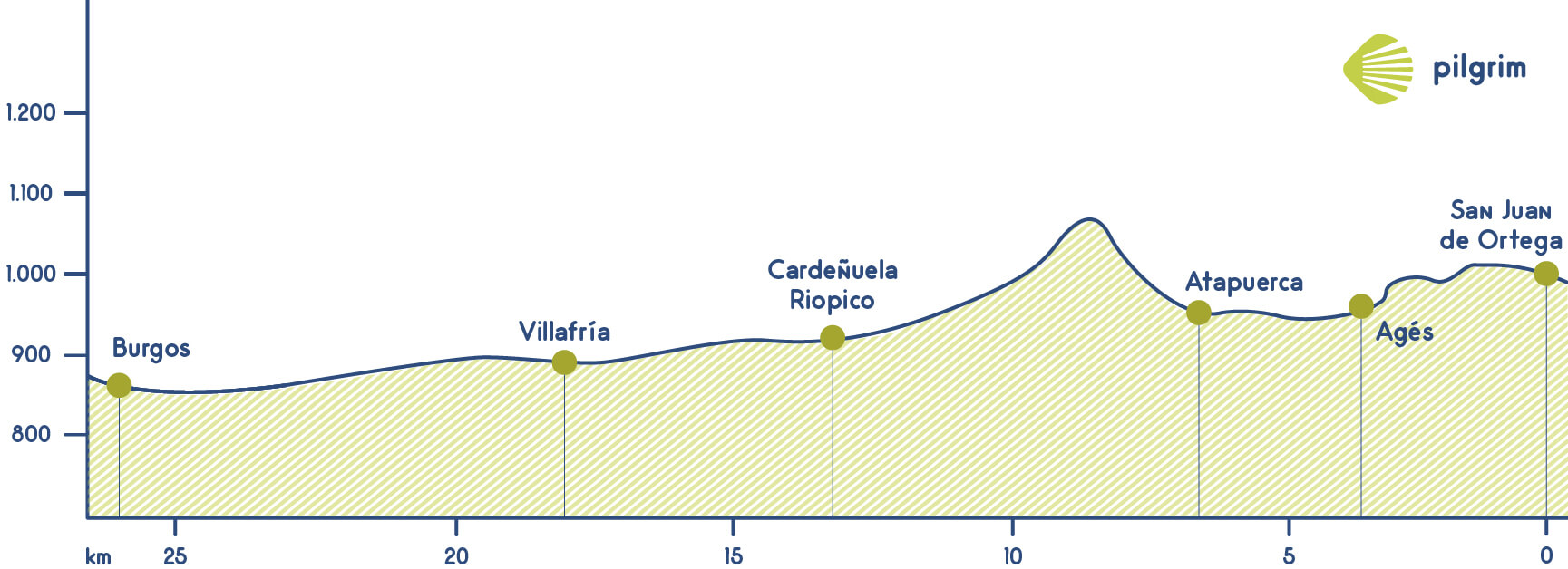
You leave San Juan de Ortega through a national road. Then you will go through the right that will lead you to Agés, a wonderful village where you can have breakfast and rest. You can visit its church and also its temple, called Templo de San Miguel.
Atapuerca is located just two kilometres and a half from Agés. To get there you will go through a local road. If you want to visit this site you should leave the village through the same road until see a huge image of a pilgrim that will indicate you the way. You will see a prohibition sign to all non-army people so now you will turn right. There are some fake indications here so you have to be careful.
The ascent to Atapuerca is not very complicated, but you have to be careful. This part will conclude once you get to the highest part, the Cruz de Madre cross where you can see all the Castilian plain and also today’s goal: Burgos. In this plain took place the Battle of Atapuerca. This was the point used in the 11 century to divide Spain.
Now you will descend through a path a little bit irregular and uncomfortable. Now you will go through the left to het to Villalval. Now you will descend through a path a little bit irregular and uncomfortable. Now you will go through the left to het to Villalval. You will leave the village through a local road that will lead you to Cardeñuela Riopico where you can find many hostels and also many establishments.
Then you will go to Burgos, but first you will stop in Orbajena Riopico that has many basic services. You will cross the train tracks a little bit after and then you should decide which way you are going to follow to enter in one of the most populated cities in Castile.
You can go through the traditional route that goes next to the airport and goes through a long straight path of four kilometres or go through Castañares. It is one kilometres longer but you will do the last metres through a wonderful park. Now you are close to Burgos where the wonderful Catedral de Santa María de Burgos cathedral is located. This cathedral if from the 12 century and it’s a gothic building.
We have reached Burgos, where you will find the awesome Cathedral of Saint Mary of Burgos, from the 12th Century, with its clearly gothic structure. It has inside load of treasures such as Cid Campeador’s tomb.
Remember.
We walk by your side! If you have any doubts about this stage or about other stages, please contact us, we will help you. Have a nice Way, Pilgrim!
What to eat
- Roasted suckling lamb
- Grilled lamb chops
- “Olla podrida” (a typical meat and vegetable stew)
- Typical black pudding from Burgos
- Queso de Burgos
- Sopa castellana (a typical soup from Castile made with garlic egg, Parma ham and paprika)
- Crayfish
Bear in mind
There are lots of part of this stage that are not able for people with reduced mobility. It is a little bit complicated for them from Atapuerca to Burgos. We reccommend them to get to Burgos through Santovenia de Oca, Zaldueno and Ibeas de Juarros.
What to see
| Villages |
Public Hostel |
Bike rental |
Medical assistance |
Coffe bar |
Cash machine |
Pharmacy |
Hotel |
Touristic Information |
Guesthouse |
Restaurant |
Supermarket |
Veterinarian |
| San Juan de Ortega |
✔ |
|
✔ |
✔ |
|
|
✔ |
|
|
|
✔ |
|
| Agés |
✔ |
|
|
✔ |
|
|
|
|
|
|
✔ |
|
| Yacimientos de Atapuerca sites |
✔ |
|
|
✔ |
|
|
✔ |
✔ |
✔ |
✔ |
✔ |
|
| Olmos de Atapuerca |
✔ |
|
|
✔ |
|
|
✔ |
|
|
✔ |
|
|
| Cardeñuela Riopico |
✔ |
|
|
✔ |
|
|
✔ |
|
|
✔ |
✔ |
|
| Orbaneja Riopico |
|
|
|
✔ |
|
|
✔ |
|
|
|
|
|
| Villafría |
|
|
|
✔ |
✔ |
|
✔ |
|
✔ |
✔ |
|
|
| Gamonal (Barrio de Burgos) |
|
✔ |
✔ |
✔ |
✔ |
✔ |
✔ |
|
✔ |
✔ |
✔ |
✔ |
| Burgos |
✔ |
✔ |
✔ |
✔ |
✔ |
✔ |
✔ |
✔ |
✔ |
✔ |
✔ |
✔ |
