Today’s stage goes through a mountain’s landscape and lonely paths where you can think and be on your own with yourself. You can divide this stage into two, the first one has no problems and goes through small typical villages of the Way, and the second one starts in Villafranca where it begins the ascent to the Montes de Oca mount. You will be accompanied just by the trees and the wind.

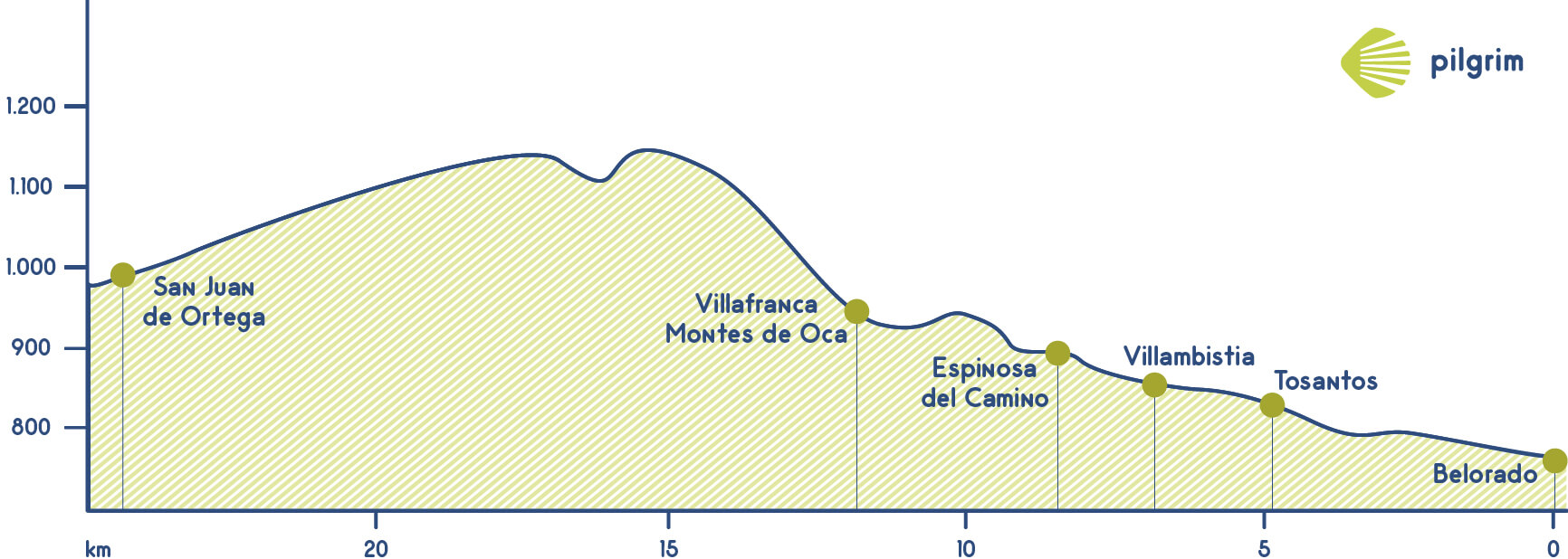
You will leave Belorado through the Calle de Hipólito López Bernal street and the Avenida del Camino de Santiago avenue to return to the N-120. You will also cross the Tirón river. You will walk through a path parallel to the national road up to a petrol station, where you will get a path that will lead you to Tosantos, this village will be your first stop.
A rest area will welcome you at the entrance of this typical village, where you can find a hostel and a coffee bar to have breakfast. You will also see a sanctuary that was built on a mountain, the Ermita de la Virgen de la Piedra hermitage. In this village there are some caves that used to be a shelter for hermits that worship this virgin. A left path will lead you to the next village: Villambistia. this is a small village that has a lovely church devoted to San Esteban, inside you will see Renaissance altarpieces. Inside you will see Renaissance altarpieces. It has a spring and according to the legend its water has healing powers. According to the legend all pilgrims that get with water recover their vitality and tiredness.
After refreshing in this spring you will continue to Espinosa del Camino, crossing again the N-120. In this village you can rest for a while and also eat in any of its establishments. After going through a little hill you will get to an old Mozarabic monastery called San Félix that was built over a Roman village. It is believed that in this monastery are buried the mortal remains of Burgos’ founder and also Conde de Castilla, Diego Porcelos.
You will return to the path that goes parallel with the N-120 through its right side and you will see Villafranca de Montes de Oca. Before starting the ascent, you will get all the necessary things such as food snack and water because there are 12 kilometers to get to the next village and between this two villages there are any services. During your stop to get all the necessary things you can visit the Iglesia de Santiago church, its Perdón door is just open in the Jacobean year. This temple has a Baroque chapel that has inside three images and a baptismal font made with a huge natural shell. You will leave this church and also the old pilgrim’s hospital to walk through the hardest part of today’s stage: the ascent to San Juan de Ortega.
This ascent is through the Montes de Oca mount, this is a lovely place that will be very complicated to pilgrims. Nowadays the fact of being along while crossing this mountain is perfect to enjoy landscapes. A long time ago the complexity was not the only problem, pilgrims needed to be careful with all the criminals there used to be in this area to steal all the possessions. Nowadays the fact of being along while crossing this mountain is perfect to enjoy landscapes. This part of the way is full of trees.
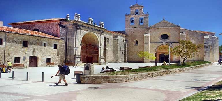
After two kilometers of ascent you can rest a little bit in two viewpoints called San Millán and Demanda, after these two viewpoints the slopes are easier. You will go through a forest path that has a monument to all people who died during the Spanish Civil War. You will cross the Catarrón river through a small bridge. Now it comes the last effort to ascent Alto de la Pedraja that is 1,150 meters high to get to a temple devoted to San Nicolás de Bari; this temple was built by San Juan de Ortega. This Saint whose original name was Juan de Velázquez was a Santo Domingo de la Calzada’s disciple; he dedicated his life to helping pilgrims and also paying the construction of bridges, hostels and roads. Su gran obra fue esta iglesia monacal, testigo cada año del famoso “Milagro de la Luz”. Every 21st of March and 22nd of September takes place a wonderful miracle, the sunlight through the window to illuminate the Annunciation. If you get there in this date you should see this miracle, it takes place approximately at 5:00 pm it is perfect to conclude today’s stage.
What to see
Please remember:
We walk by your side! If you have any doubt about this stage or about other stages, please contact us, we will help you. Have a nice Way, Pilgrim!
What to eat
- Roasted suckling lamb
- Typical black pudding from Burgos
- Typical green cheese from Burgos
- Typical honey
- Yemas (pastries made mainly with egg yolk and sugar)
- Huesecillos fritos (pastries made mainly with flour, sugar and anisette)
Bear in mind
This stage is impossible for people with reduced mobility. It is necessary to go to San Juan de Ortega in any kind of transport. For cyclists, this stage is also a little bit complicated in some parts.
If its rainy is probably that the paths are full of mud; in this case the best option is to go through the N-120 to get to Villafranca.
What to see| Towns | Public Hostel |
Bike rental |
Medical assistance |
Coffe bar |
Cash point |
Pharmacy |
Hotel |
Touristic Information |
Guesthouse |
Restaurant |
Supermarket |
Veterinarian |
|---|---|---|---|---|---|---|---|---|---|---|---|---|
| Belorado | ✔ | ✔ | ✔ | ✔ | ✔ | ✔ | ✔ | ✔ | ✔ | ✔ | ✔ | |
| Tosantos | ✔ | ✔ | ✔ | |||||||||
| Villambistia | ✔ | ✔ | ✔ | |||||||||
| Espinosa del Camino | ✔ | ✔ | ✔ | ✔ | ||||||||
| Villafranca / Montes de Oca | ✔ | ✔ | ✔ | ✔ | ✔ | ✔ | ✔ | ✔ | ||||
| San Juan de Ortega | ✔ | ✔ | ✔ | ✔ | ✔ |
Towns


